


![]()
Difficulty: easy
Fitness: easy
Fear of heights: easy
Surefootedness: easy
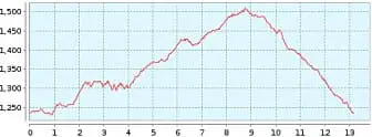
Distance: 13,17 km
Duration: 3:00 h
Heights: ![]()
![]() 339
339
Start/End:
Las Arenas Negras
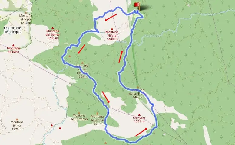

Hike 67: Chinyero/Montana de la Cruz
All good things come in threes, so I hiked the Chinyero again. This time counterclockwise in a big loop. I parked again at the Arenas Negras car park. The approach from the TF-373 on the Pista Arenas Negras is bumpy. If you don't want to get into trouble with the rental car company, drive really slowly here. Be sure to approach the car park from below. There is a large dent at the top where cars can sometimes come into contact with the ground.
Go up from the car park and then turn right. Shortly afterwards, you reach an open plateau where the sun provides plenty of warmth even in winter. Canary Island pines grow in the midst of the volcanic landscape. Before the trade wind clouds shroud the Teide, you can see it from its beautiful eastern flank. After about 2 km, we keep to the left on an invisible path (follow the GPS). It leads us up to the Pista Canal de Vergara, where we turn hard right.
We follow this path until we reach Montana de la Cruz. It is possible to climb up. However, the summit is forested and thus no views are to be expected. At this ascent point, however, there is the first view of the Chinyero with the Teide behind it. We stay on the main hiking trail and walk around the Chinyero. It is still rarely visible, but this changes as we go on and it is constantly in view. In the last third, the path leads gently down along the edge of the crater plain to the Arenas Negras.
The hike is very good for warming up for a hiking holiday. As you do not cross the crater plain, surefootedness is easy and you walk large parts in the shade. If you expect a bit more spectacle, I recommend walking Tour 19 in an anti-clockwise direction.
A detailed description of the route and the GPS track can be found in the Hiking Guide Tenerife.

Photo Gallery