


![]()
Difficulty: middle
Fitness: middle
Fear of heights: easy
Surefootedness: easy
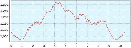
Distance: 10,44 km
Duration: 3:30 h
Heights: ![]()
![]() 442
442
Start/End:
1,5 km from Erjos
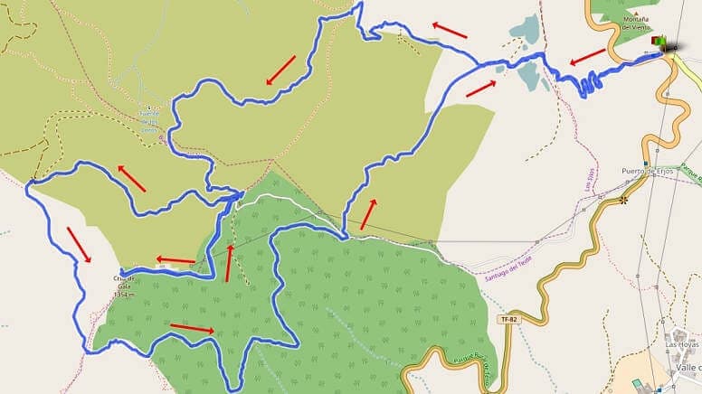

Hike 25: Cruz de Gala
The rather quiet hike starts at the Fleytas restaurant on the main road 1.5 kilometres from Erjos. At the beginning, you should check the GPS route more often and go back if there are any deviations. Even small deviations can lead to finding yourself in the middle of dense scrub with thorns.
Once you have completed the first part, you go up to Cruz de Gala. In good weather, the view extends all the way to Masca. You then have to walk back up the asphalt road. The easy ascent and descent takes a total of 30 minutes.
We continue on the main hiking trail. We circle the Cruz de Gala and halfway through the tour we are faced with the ascent to Pico Gala. The ascent and descent takes about 20 minutes. Because of the cloudy summit we refrain from doing so.
The most beautiful part of the hike through open terrain follows. After an easy descent with views of the Teide, we reach the plain, where we meet up with the outward route and hike in switchbacks back to the starting point. The tour is not spectacular, but offers but offers a variety of views and landscapes.
A detailed description of the route and the GPS track can be found in the Hiking Guide Tenerife.
Photo Gallery