


![]()
Difficulty: middle
Fitness: middle
Fear of heights: high
Surefootedness: high
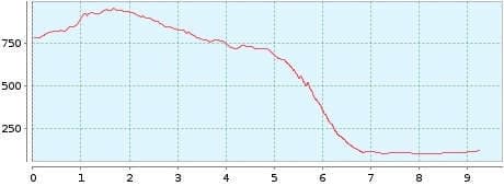
Distance: 9,26 km
Duration: 4:30 h
Heights: ![]() 205
205 ![]() 867
867
Start: Tabaiba Pass
End: Buenav. Norte


Hike 28: Cumbre de Baracan/Risco steep track
This spectacular tour is moderately difficult in terms of profile. At the end, the descent through the Riscosteig hurts your joints. But it is worth it. You need to have a head for heights, but the hike is not really dangerous, because you always have enough distance to the edge of the cliff. It goes without saying that this hike is only done in dry weather. At the end of the description, I give a tip on how to make the difficulty much less difficult.
Contrary to other hiking guides I do not plan this tour as an ascent and descent through the Riscosteig, but start at the Tabaiba Pass. First we park the car at the end point in Buenavista del Norte and take bus 355 towards Masca at 9:30. Although there is no stop at the Tabaiba Pass, the driver stops for us. That is standard on Tenerife. Otherwise you would have to continue to El Carrizal and hike 1.4 km back to the pass.
From the pass a wonderful section begins on the Cumbre de Baracan. In the morning, there is still very good visibility here and we can see La Gomera within reach. The green mountain ranges of Teno impress with their gentle simplicity. The Teide is also clearly visible. We reach Teno Alto, where it is possible to stop at the only bar, and first walk a short distance on the asphalt road. Now the Camino del Risco leads to an old Guanche meeting place. Up to here, the hike is easy.
Shortly afterwards we reach the highest point of the precipice. We are deeply impressed by the breathtaking views into the rocky abyss. The north coast to Puerto de la Cruz lies at our feet. Not for nothing did the Guanches live here. Here they were protected from the Spanish attacks.
Now we descend the Riscosteig and enjoy the scenery. Now it becomes clear why the tour is moderately difficult. With the utmost concentration, step after step has to be mastered. At the bottom, a kind of barranco stretches through the valley in the glaring sunlight until the Camino finally reaches the road. From here it is another 2.5 km to Buenavista del Norte. This impressive experience is one of Tenerife's absolute top hikes.
A detailed description of the route and the GPS track can be found in the Hiking Guide Tenerife.
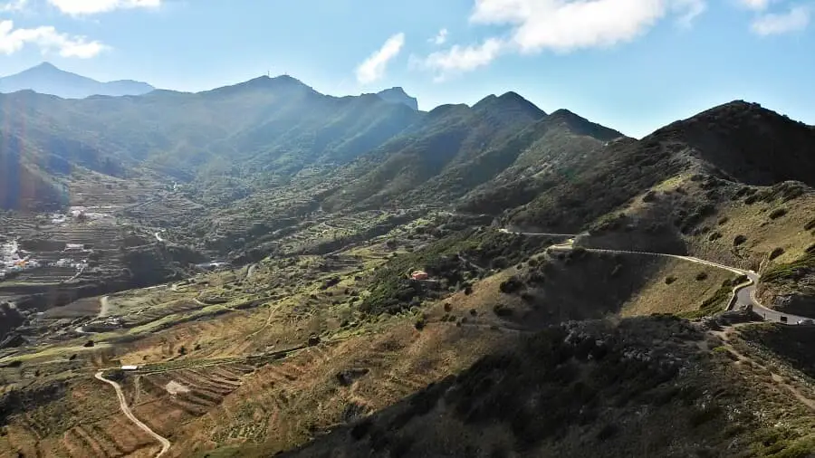
Photo Gallery